
Nepal Flood Wave Was the Result of a Complex Chain
The Nepal flood wave that devastated communities along the Nepal-China border in August was not caused by one isolated event, according to a new scientific analysis. Researchers say a combination of geological instability, glacier changes, thawing permafrost, unusually warm conditions and previous damage to the mountain landscape helped create the catastrophic chain.
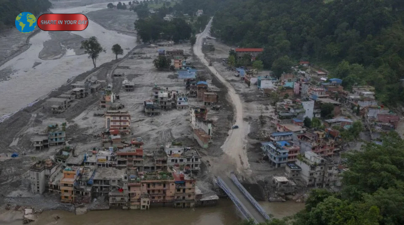
The disaster began on August 26, when a huge section of rock and glacier ice broke away from Langtang Lirung in Nepal’s Himalayas. The collapsing material plunged thousands of feet into a valley, generating a powerful avalanche that rapidly transformed into a debris flow and then a destructive flood wave.
More than 1,300 people were reported dead, while thousands remained missing in the aftermath, according to reporting published this week. The disaster also destroyed or damaged roads, bridges, settlements and critical infrastructure across the affected region.
Researchers from World Weather Attribution, or WWA, examined the event to determine how different environmental conditions contributed to the collapse. Their analysis concluded that human-caused warming played an important role in preparing the mountain for failure, although the disaster itself resulted from several interacting processes rather than a single cause.
How the Nepal Flood Wave Started
The initial trigger was a massive rock-and-ice collapse from Langtang Lirung.
According to the WWA analysis, the collapse occurred at an elevation of approximately 5,150 meters. A huge volume of rock and ice detached from the mountain and accelerated toward the valley below.
The impact released enormous energy. WWA estimates that the initial collapse produced energy equivalent to roughly a magnitude 5.5 earthquake. The resulting avalanche rapidly transformed as it moved downstream, carrying rock, ice, sediment and water with it.
The event then became more than a conventional landslide.
As the avalanche entered the river system, it transformed into a debris flood and eventually a water-dominated flash flood. WWA estimates that the resulting flood traveled downstream at an average speed of about 188 kilometers per hour in its early cascade.
That extraordinary speed left very little time for communities downstream to respond.
The European Space Agency also reported that the flood originated from a rapid slope failure associated with glacier collapse at Langtang Lirung. Satellite observations helped scientists map the extent of the resulting inundation and destruction.
1. Climate Change Increased Mountain Instability
One of the central findings of the new research is that long-term warming helped create conditions in which the mountain became increasingly unstable.
The Himalayas are warming rapidly, and researchers say the effects are particularly important at high elevations. As temperatures rise, the elevation at which water freezes is also moving upward.
WWA found that the Himalayan zero-degree line has risen by more than 100 meters per decade. That matters because many mountain slopes depend on permanently frozen material to help maintain structural stability.
The researchers also found that July and August temperatures in the affected area were approximately 1.5 degrees Celsius warmer because of human-caused climate change.
That warming does not mean climate change alone suddenly caused the collapse. Instead, it altered the physical environment over time, potentially making a major failure more likely.
This distinction is important.
Scientists are not describing the disaster as a simple case of rising temperatures directly producing a flood. Instead, they are describing a chain in which warming changed glaciers, frozen ground and water movement, creating conditions that made a geological failure more dangerous.
2. Thawing Permafrost May Have Weakened the Mountain
Permafrost is another critical piece of the puzzle.
In high mountain environments, frozen water within rock and soil can act like a natural binding agent. When that frozen material remains intact, it can help stabilize slopes.
As temperatures increase, however, permafrost can thaw.
That process allows more liquid water to penetrate cracks and can reduce the strength of rock formations. Walter Immerzeel, a mountain hydrologist at Utrecht University and a contributor to the analysis, said thawing permafrost can weaken rock and allow additional water to enter mountain slopes.
This creates a potentially dangerous feedback mechanism.
Warmer temperatures can thaw frozen material. More water can enter fractures. Weakened rock can then become more vulnerable to gravity, glacier movement and other geological forces.
In a landscape as steep and heavily glaciated as the Himalayas, even relatively small changes can have consequences over long periods.
The WWA researchers therefore describe climate change as a form of long-term “preconditioning” rather than as a single immediate trigger.
3. The Glacier Had Been Shrinking and Thinning
Changes to the Langtang-Lirung Glacier also appear to have contributed to the mountain’s instability.
The glacier has experienced substantial thinning and retreat over recent decades, particularly since around 2010, according to the scientific assessment cited by CNN.
Glacier retreat can affect surrounding slopes in several ways.
As ice disappears, previously supported sections of rock can become exposed. Meltwater can also enter cracks and weaknesses in the underlying rock.
That water may eventually freeze, melt again and move through the mountain, contributing to physical deterioration.
The WWA researchers found that glacier change was an important component of the broader sequence of processes affecting the slope.
The disaster therefore illustrates why scientists increasingly examine glaciers and surrounding rock as interconnected systems.
A glacier is not simply a block of ice sitting on top of a mountain. Its movement, retreat and interaction with rock can influence the stability of the terrain around it.
4. The 2015 Earthquake May Have Left a Legacy
Climate-related processes were not the only factors identified by researchers.
The scientists also pointed to the possibility that the magnitude 7.8 earthquake that struck Nepal in 2015 weakened the mountain landscape.
The earthquake triggered a major rock-and-ice avalanche in the Langtang region. Researchers believe that previous damage from that event may have left sections of the mountain more vulnerable to subsequent landslides and collapse.
This is an important reminder that major mountain disasters can have long memories.
A large earthquake can fracture rock, alter slopes and change drainage pathways. The resulting weaknesses may persist for years.
In the case of Langtang Lirung, the 2015 earthquake was therefore considered a possible geological precondition for the 2026 failure rather than a direct trigger occurring at the moment of the disaster.
Scientists continue to distinguish between these factors because identifying the exact sequence is important for understanding future hazards.
5. Extreme Warmth Added More Meltwater
Weather in the months before the collapse provided another important part of the puzzle.
The region experienced unusually heavy snowfall during October and early November 2025. Then July and August 2026 brought exceptionally warm conditions.
That combination may have increased the amount of meltwater moving through the mountain environment.
Researchers found that temperatures in July and August were unusually high, while longer-term warming had already changed the glacier and permafrost systems.
The available evidence does not establish the same direct climate connection for precipitation and snowfall. WWA noted that the rugged terrain and limited observations across the Himalayas make it difficult to determine precisely how climate change has altered some precipitation patterns.
That uncertainty does not eliminate the other findings.
Instead, it shows why scientists describe the disaster as a cascade involving several interacting mechanisms.
Why the Flood Became So Destructive
The scale of the initial collapse was extraordinary.
WWA estimates that approximately 116 million cubic meters of rock and ice initially broke away from the mountain, according to reporting based on the analysis. The material then moved rapidly downslope and interacted with water, sediment and existing river channels.
That transformation made the event particularly destructive.
A rockfall alone might affect a relatively limited area around its source. But once huge amounts of rock and ice enter a river system, the hazard can move far beyond the original collapse zone.
The resulting flow can pick up additional sediment, trees, water and debris.
It can also travel through valleys that contain roads, bridges, hydropower facilities, towns and other infrastructure.
ESA satellite imagery showed how the resulting flood extended far downstream and affected communities along river valleys in northern Nepal.
Why Early Warning Was So Difficult
One of the most concerning findings from the analysis involves the limits of conventional early-warning systems.
The researchers said the event was fundamentally different in its size, speed and complexity from many hazards for which warning systems are designed.
The initial collapse occurred high in the mountains, but the resulting cascade transformed rapidly as it moved downstream.
That creates a difficult forecasting problem.
A warning system needs time to detect a hazard, determine where it is going and communicate an appropriate alert to people who may be affected. When a landslide rapidly becomes a debris flow and then a major flood, those stages can unfold faster than traditional systems can respond.
WWA concluded that existing warning systems could not have provided sufficient lead time for an event of this type.
A separate analysis published in Nature’s npj Natural Hazards also emphasized the need for warning systems that cross national boundaries, because mountain hazards can move from one country to another much faster than institutions can respond.
What the Nepal Flood Wave Reveals About the Himalayas
The Nepal flood wave demonstrates how climate change can interact with geological hazards.
Floods, landslides, glacier collapses and rockfalls are not entirely new phenomena in the Himalayas. The difference is that a warming climate can alter the physical conditions under which those hazards occur.
Glaciers are retreating in many areas.
Permafrost is becoming increasingly vulnerable to thaw.
Snow and ice can melt more rapidly during periods of extreme heat.
At the same time, communities and infrastructure continue to occupy narrow valleys where there are few alternatives for roads, hydropower facilities and settlements.
This combination creates a complicated risk environment.
Researchers therefore caution against treating climate change as a simple explanation for every individual landslide. Instead, the evidence points toward a changing background environment in which multiple hazards can interact.
Scientists Still Acknowledge Uncertainty
The WWA analysis provides an important scientific assessment, but it is also important to understand its status.
The report uses established attribution methods and draws on observations, climate data and modeling. However, the analysis itself had not yet undergone conventional peer review when the initial findings were published.
That means some details may change as additional observations become available and researchers conduct further studies.
Other scientists have also been investigating the event using satellite imagery, seismic measurements and field observations.
For example, researchers studying the disaster have reconstructed the sequence of the initial avalanche and subsequent flood using multiple data sources. A separate preprint cautions that some aspects of the flood’s exact water source and downstream dynamics remain difficult to distinguish with currently available open data.
Such uncertainty is normal after an unprecedented disaster.
The scientific picture is likely to become clearer as researchers gain access to more satellite data, field measurements and information from affected communities.
A Warning for Other High-Mountain Regions
The implications extend beyond Nepal.
Mountain communities across the Himalayas depend heavily on rivers, glaciers and steep valleys. These same regions also contain rapidly developing infrastructure and growing populations.
The combination creates difficult choices for disaster planners.
The World Weather Attribution researchers described the situation as particularly challenging because there is limited habitable land in many mountain regions. Moving settlements and infrastructure away from vulnerable river valleys may not always be practical.
That means adaptation will likely require better monitoring, stronger cross-border warning systems, improved hazard mapping and careful infrastructure planning.
At the same time, the researchers argue that reducing greenhouse gas emissions remains central to slowing the long-term warming that is changing high-mountain environments.
What Happened in Nepal, in Simple Terms
The chain of events can be summarized in five stages:
- Long-term warming altered the mountain environment.
- Glacier retreat and thinning changed the relationship between ice and rock.
- Permafrost thaw and meltwater potentially weakened the slope.
- Previous geological damage, including the 2015 earthquake, may have contributed to instability.
- A huge rock-and-ice collapse transformed into a rapidly moving debris and flood wave.
No single factor adequately explains the entire disaster.
Instead, scientists describe a cascading system in which geological and climate-related processes interacted over years before producing a catastrophic event within minutes.
The Bigger Lesson From the Nepal Flood Wave
The Nepal flood wave is now becoming an important case study in how climate change can interact with natural hazards.
The August disaster was not simply a flood, landslide or glacier collapse. It was a chain reaction that began high on a Himalayan mountain and rapidly propagated through river systems and communities downstream.
Scientists say decades of warming helped create conditions that made the landscape more vulnerable. At the same time, geological history, glacier behavior, permafrost conditions and unusually warm weather all contributed to the final outcome.
The findings do not mean every future Himalayan disaster can be predicted.
They do, however, show why monitoring mountain slopes and glaciers is becoming increasingly important as the region warms.
For communities living downstream, the challenge is not only understanding where hazards originate. It is also understanding how quickly one hazard can transform into another.
The disaster in Nepal demonstrates that a collapse several kilometers above a valley can become a major flood downstream in a matter of minutes.
As scientists continue examining the event, the central message is becoming clearer: understanding the interaction between climate change, glaciers, permafrost and geological instability will be essential for assessing future risks across the Himalayas.