
SoCal Weather Relief Revealed Before Tropical Moisture Arrives
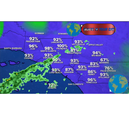
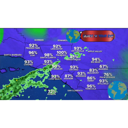
Southern California is experiencing a welcome change in SoCal weather conditions after an extended period of intense heat, with temperatures falling below seasonal norms and tropical moisture increasing the potential for rain across parts of the region.
The shift offers temporary relief for communities that recently endured scorching temperatures. However, the changing weather pattern also brings new concerns, including increased humidity, possible showers and thunderstorms, and hazardous surf conditions along the Southern California coast.
According to ABC7 Los Angeles, a cooler weather pattern moved into the region as an area of lower pressure reduced temperatures. Forecasters said the relief from the heat was expected to continue before temperatures gradually began warming again.
SoCal Weather Brings a Break From Extreme Heat
For much of Southern California, the arrival of cooler conditions marked a significant change from the extreme temperatures experienced earlier in the season.
The SoCal weather pattern has been influenced by a trough of lower pressure, allowing temperatures to fall closer to or below normal levels. Los Angeles and Orange County, inland valleys, mountain communities and desert areas can experience dramatically different conditions, making regional forecasts particularly important.
ABC7 reported that the cooler air was expected to provide a temporary break before temperatures began gradually climbing again.
While cooler temperatures can provide welcome relief, the change does not necessarily mean that Southern California’s weather will remain calm. Forecasters were also monitoring tropical moisture moving toward the region.
That combination of changing temperatures and additional moisture has created a more complicated forecast for residents and travelers.
Tropical Moisture Raises Rain Chances
One of the major developments affecting the SoCal weather forecast is the arrival of tropical moisture associated with Hurricane Marie, which remained offshore in the Pacific.
ABC7 reported that the system was expected to remain well away from Southern California rather than make landfall. Even so, moisture associated with the storm could move into the region and increase humidity and the potential for showers.
Weather systems do not need to make a direct landfall to affect communities hundreds of miles away. Tropical storms can generate large swells, transport significant moisture and alter atmospheric conditions over broad areas.
For Southern California, the primary concerns were not expected to come from hurricane-force winds. Instead, residents were urged to pay attention to changing rain chances, higher humidity and dangerous conditions near the coast.
ABC7 previously reported that some areas could receive substantial rainfall if the tropical moisture interacted favorably with local atmospheric conditions.
Rainfall Can Create Localized Hazards
Rain is not unusual in Southern California, but intense or sudden rainfall can create challenges, particularly after extended periods of dry weather.
A changing SoCal weather pattern can affect roads, drainage systems and areas vulnerable to flash flooding. Drivers may encounter slippery conditions when rain first begins to fall because oil and other materials can accumulate on road surfaces during dry periods.
Mountain and foothill communities can also face increased risks when heavy showers develop near steep terrain. Meanwhile, urban areas may experience localized flooding if rainfall falls faster than drainage systems can manage.
Residents were encouraged to monitor official forecasts and weather alerts because rainfall totals can vary significantly from one community to another.
A forecast for showers does not mean that every neighborhood will receive the same amount of rain. Tropical moisture can produce scattered and uneven precipitation, meaning some communities may remain mostly dry while others experience heavier downpours.
Southern California Beaches Face Dangerous Surf
The coastal impact of the offshore storm has become one of the most important elements of the changing SoCal weather conditions.
Even though Hurricane Marie remained far from the California coast, it generated powerful ocean swells that affected beaches across Southern California.
The Associated Press reported that some south-facing beaches experienced surf reaching up to 10 feet, while dangerous rip currents created life-threatening conditions for swimmers and surfers.
Officials urged people to avoid entering dangerous water and to stay away from jetties and other hazardous shoreline areas.
High surf can create risks that are not immediately obvious to visitors. Powerful waves may sweep across rocks, while strong currents can pull swimmers away from shore.
The dangerous conditions demonstrated why weather awareness is especially important along the Southern California coastline.
A Complex Weather Pattern Across the Region
One reason SoCal weather forecasts can be challenging is the enormous geographical diversity of Southern California.
Coastal communities may experience mild temperatures and marine clouds while valleys and inland locations become significantly warmer. Mountain areas can see entirely different conditions, while desert communities often experience some of the highest temperatures in the region.
During the recent weather pattern, Los Angeles and Orange counties were seeing cooler conditions while forecasters watched for tropical moisture and potential showers. Beach communities also faced a separate threat from elevated surf.
This means residents cannot always rely on a general forecast for Southern California. Checking conditions for a specific city or neighborhood can provide a more accurate picture of what to expect.
What Hurricane Marie Means for Southern California
The presence of Hurricane Marie in the Pacific attracted attention because tropical systems can occasionally influence California weather patterns.
However, an offshore hurricane does not automatically mean that Southern California will experience a direct tropical cyclone impact.
In this case, the storm’s primary influence involved tropical moisture and hazardous ocean conditions rather than a direct landfall.
The Associated Press reported that Marie was expected to weaken without reaching the California coast, although its effects on ocean conditions and local weather remained significant.
This distinction is important. Residents should pay attention to official weather forecasts rather than assuming that every hurricane in the eastern Pacific will strike Southern California.
At the same time, offshore storms should not be ignored. Large ocean swells can travel long distances and create dangerous surf far from a storm’s center.
Temperatures Could Begin Rising Again
Although the cooler SoCal weather pattern offered relief from the heat, forecasters expected temperatures to gradually increase after the temporary cooling period.
Weather patterns can change quickly when high pressure strengthens over California. A stronger area of high pressure can suppress cloud formation and allow temperatures to rise significantly.
Southern California has experienced repeated periods of extreme heat during the warmer months. As a result, even a brief break from high temperatures can be followed by another round of warmer weather.
Residents should continue monitoring updated forecasts, particularly those living in inland valleys, deserts and other locations that can experience extreme heat.
ABC7 has repeatedly reported that temperature patterns across the region can shift quickly as high- and low-pressure systems move across the western United States.
How Residents Can Prepare for Changing SoCal Weather
Changing SoCal weather conditions require flexibility and preparation.
People heading outdoors should check the latest forecast before making plans. A day that begins with mild conditions can become hotter, wetter or windier depending on how the weather pattern develops.
Drivers should be especially careful during periods of rain, particularly after a prolonged dry spell. Reduced visibility and slick roads can increase the risk of accidents.
Beach visitors should also pay close attention to warnings from lifeguards and local authorities. Dangerous rip currents and large waves can occur even when skies appear relatively calm.
Residents can prepare by:
- Monitoring official weather forecasts and alerts.
- Avoiding unnecessary travel during severe rainfall.
- Keeping extra distance between vehicles on wet roads.
- Avoiding dangerous ocean conditions.
- Staying hydrated when temperatures begin rising again.
- Checking local forecasts before hiking or visiting mountain areas.
Why Accurate Weather Information Matters
Weather forecasts provide communities with critical information about potential hazards, but conditions can change as new atmospheric data becomes available.
That is particularly true when tropical moisture interacts with local weather systems.
Forecasters continually update predictions as satellite observations, radar information and computer models provide a clearer picture of developing conditions.
For residents, the most useful approach is to follow trusted local meteorologists and official weather agencies rather than relying on outdated social media posts or unverified weather claims.
The recent pattern affecting Southern California illustrates how quickly conditions can change. The region moved from prolonged heat toward cooler temperatures and increasing moisture, while coastal communities simultaneously faced hazardous surf.
The Bottom Line on SoCal Weather
The latest SoCal weather pattern has delivered a much-needed break from extreme temperatures, but the relief comes with new weather concerns.
Cooler conditions and below-average temperatures have been accompanied by increased humidity and the possibility of showers as tropical moisture moves toward the region. Meanwhile, Southern California beaches have faced dangerous surf and powerful rip currents linked to Hurricane Marie far offshore.
The system was not expected to make landfall in California, but its indirect effects demonstrated how distant storms can still influence local weather and coastal conditions.
As temperatures eventually begin rising again, Southern California residents should remain prepared for another transition in the region’s constantly changing weather pattern.
For now, the combination of cooler temperatures, potential rainfall and hazardous ocean conditions makes monitoring the latest SoCal weather updates especially important. Local conditions can vary widely, and the forecast may continue to evolve as meteorologists receive new information.
Residents and visitors are encouraged to follow official weather alerts, exercise caution near the ocean and prepare for changing conditions throughout Southern California.