
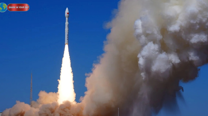
China Diting Satellites Enter Orbit
China Diting satellites have entered orbit as Beijing expands the country’s capabilities in space-based radio-frequency sensing.
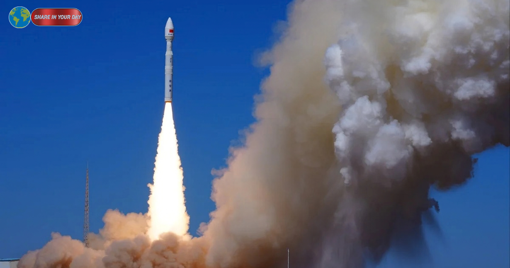
Three Diting-01 satellites were launched on September 20 aboard a Lijian-1 Y18 rocket from the Jiuquan Satellite Launch Centre. The rocket carried nine satellites in total, with the three Diting spacecraft successfully reaching their planned orbit. SSouth China Morning Post+1
The launch represents an important development in China’s commercial space sector because the Diting spacecraft are designed to detect and locate radio-frequency signals across large areas.
That capability has both civilian and potential security applications.
According to the South China Morning Post, the satellites can track signals associated with warships, radar systems and electronic jammers. Their ability to identify where electromagnetic signals originate could provide information about activity on land and at sea. SSouth China Morning Post
What Are China Diting Satellites Designed to Do?
At their core, the Diting satellites are radio-frequency sensing spacecraft.
Radio-frequency sensing involves detecting electromagnetic signals transmitted by objects and systems on Earth. Those signals can come from communications equipment, radar systems, navigation systems and other electronic devices.
Instead of relying exclusively on ground-based monitoring stations, satellites can observe much wider areas.
The three-spacecraft configuration is particularly significant because multiple satellites can observe the same signal from different positions. Comparing those observations can help determine the approximate location of a transmitter.
A description of the Diting constellation published after the launch says the system is designed to provide wide-area electromagnetic-spectrum awareness and rapidly locate radio transmitters. TTaibo
This means the technology is not simply about “listening” to radio signals.
It is also about determining where those signals originate.
Why the Satellites Are Called Diting
The name Diting comes from Chinese mythology.
Diting is traditionally described as a mythical creature associated with the underworld deity Ksitigarbha. According to the description cited by the South China Morning Post, the creature is capable of identifying things through listening. SSouth China Morning Post
The name therefore reflects the fundamental purpose of the spacecraft: detecting information that cannot necessarily be seen with conventional optical imaging.
The concept is particularly appropriate for radio-frequency sensing because a transmitter does not need to be visually visible for its electromagnetic emissions to be detected.
A ship, radar installation or communications system may be difficult to identify through ordinary satellite imagery. If it is transmitting radio energy, however, its emissions can potentially reveal its presence and location.
How Radio-Frequency Satellites Can Track Signals
The basic principle is relatively straightforward.
A transmitter on Earth produces a radio signal. A satellite equipped with specialized receivers can detect that signal from orbit.
With multiple satellites observing simultaneously, the system can compare measurements and estimate the transmitter’s location.
This is sometimes referred to as geolocation of radio-frequency emitters.
The three Diting-01 spacecraft form the first group of the planned Diting constellation. The constellation is being developed for commercial space-based RF data collection, according to information published by the companies involved in the project. TTaibo
The approach provides an important advantage over a single satellite.
A single spacecraft can detect a signal, but determining its precise origin can be more difficult. Multiple observation points provide additional information that can improve geolocation.
Potential Military and Security Applications
The technology has obvious implications for electronic warfare and intelligence gathering.
The South China Morning Post reported that the satellites can detect signals from enemy warships, hidden radar systems and electronic jammers. SSouth China Morning Post
For example, a naval vessel attempting to limit its visibility by turning off its automatic identification system could still potentially reveal itself through other electromagnetic emissions.
Similarly, an air-defense radar does not need to be visible from space to generate a detectable radio-frequency signature.
If a radar is transmitting, a suitably equipped satellite may be able to detect and geolocate its emissions.
That information could contribute to a broader electronic picture of an area.
However, detecting a signal does not automatically mean that a satellite can identify every detail about the system transmitting it. The effectiveness of any RF-sensing system depends on factors including signal strength, frequency, satellite position, atmospheric conditions, processing capabilities and the characteristics of the target transmission.
The Commercial Side of the Diting Program
One of the most notable aspects of the launch is its commercial character.
The Diting constellation is associated with Tianjin Xingkan Jiuzhou Technology, also known as StarRF, while Chang Guang Satellite Technology is involved in satellite development. TTaibo+1
Chang Guang describes itself as a company focused on the research and development of remote-sensing and communications satellites, as well as satellite information services. Its website says the company has capabilities covering satellite development, production, testing and remote-sensing data processing. JJL1 Satellite
That commercial structure is significant because space-based electromagnetic sensing was historically associated largely with government and military programs.
The Diting project indicates that some of these capabilities are increasingly being developed through China’s commercial space industry.
China’s Growing Commercial Space Industry
China has been expanding its commercial space sector alongside its state-led space program.
Commercial companies are increasingly involved in satellite manufacturing, launch services, remote sensing and data applications.
The Diting project fits into this broader trend.
Rather than building a satellite solely for conventional Earth imaging, the program focuses on information contained within the electromagnetic spectrum.
That creates potential markets beyond military applications.
Possible commercial uses include maritime monitoring, spectrum management, infrastructure monitoring and other services requiring knowledge of radio transmissions.
Information associated with the Diting constellation lists spectrum management, maritime monitoring, public safety and railway-related applications among potential uses. TTaibo+1
Why Space-Based RF Sensing Matters
The electromagnetic spectrum is increasingly important to modern economies and militaries.
Mobile networks, satellite communications, navigation systems, aviation, shipping and emergency services all depend on radio-frequency technology.
At the same time, modern military forces depend heavily on radar and communications.
Monitoring the electromagnetic environment can therefore provide information that conventional cameras cannot.
An optical satellite might photograph a ship.
An RF-sensing satellite can potentially detect that ship’s electronic emissions.
The two capabilities are complementary rather than interchangeable.
Combining optical imagery, radar imagery and RF information can produce a more detailed picture of activity across a particular region.
Diting and the Global RF-Satellite Race
China is not developing this technology in isolation.
Commercial RF-sensing companies elsewhere have already demonstrated the potential of satellite constellations to detect and locate radio transmissions.
One prominent example is US-based HawkEye 360, whose satellites use multiple spacecraft to geolocate RF emissions.
The Diting project has consequently attracted comparisons with that model. Industry reporting has described StarRF as China’s counterpart to HawkEye 360, although the companies and their markets are not identical. SSpace Security News+1
The emergence of competing commercial systems illustrates a broader transformation in the satellite industry.
Space-based sensing is no longer limited to taking pictures of the Earth.
Companies can now build businesses around detecting radio signals, analyzing electromagnetic activity and selling processed data.
What Makes the Three-Satellite Formation Important?
The three-satellite formation is central to the Diting concept.
Multiple spacecraft provide separate observation points.
When a radio signal is detected by several satellites, differences in the timing and characteristics of the received signal can help determine where the transmitter is located.
This is particularly useful for moving targets.
A ship at sea, for example, may be difficult to monitor continuously using conventional ground infrastructure. A satellite constellation can potentially observe a much larger area without requiring a physical monitoring station close to the target.
The Diting constellation is described as China’s first commercial satellite constellation using a three-satellite formation for commercial space-based RF data acquisition. TTaibo
What the Launch Does Not Mean
The launch should not be interpreted as meaning that China now has unlimited ability to monitor every radio transmission around the world.
Three satellites represent only the initial stage of a constellation.
Coverage, revisit frequency and geolocation accuracy depend heavily on the eventual number of spacecraft, their orbital configuration and the sophistication of their sensors and processing systems.
A larger constellation would generally allow more frequent observations and broader persistent coverage.
The September launch is therefore better understood as an initial operational and technology-demonstration step rather than the completion of a global surveillance network.
A New Layer of Space-Based Intelligence
The development nevertheless highlights an important direction in modern space technology.
For decades, satellite reconnaissance was strongly associated with visual imagery.
Today, the electromagnetic spectrum itself has become an intelligence source.
Radio emissions can reveal the presence of ships, communications systems, radars and other electronic equipment even when those systems are not easily visible.
That makes RF sensing a potentially valuable complement to optical and radar satellite imagery.
The Diting satellites demonstrate China’s interest in turning this capability into a commercial service as well as a potential security tool.
What Comes Next for the Diting Constellation?
The three Diting-01 satellites are the first group of the planned constellation, meaning the September 20 launch is only an initial step.
Future expansion would determine how useful the system becomes in practice.
A larger constellation could improve geographic coverage and increase the frequency with which specific areas are observed.
The commercial question will also be important.
Satellite companies must ultimately turn technical capabilities into useful data products that customers are willing to purchase.
That could include maritime monitoring, spectrum-management services and other applications outside the defense sector.
At the same time, the potential security applications mean the project will likely attract continued attention from governments and military analysts.
China’s Space Strategy Is Becoming More Diverse
The Diting launch is another example of how China’s space ambitions are expanding beyond traditional launch vehicles and communications satellites.
The country now has a growing ecosystem involving satellite manufacturers, commercial launch providers, remote-sensing companies and specialized data businesses.
Chang Guang’s stated ability to produce more than 200 satellites annually illustrates the industrial scale being developed within China’s commercial satellite sector. JJL1 Satellite
Diting adds another capability to that ecosystem.
Instead of simply observing the physical appearance of the Earth, the constellation is designed to observe the invisible electromagnetic environment surrounding it.
Conclusion: Why the Diting Launch Matters
The launch of China’s three Diting-01 satellites marks a significant development in commercial space-based radio-frequency sensing.
The spacecraft are designed to detect electromagnetic signals and help locate their sources. That could support civilian applications such as maritime monitoring and spectrum management while also providing capabilities relevant to electronic warfare and intelligence gathering. TTaibo+1
The technology is not entirely new, and China is entering a field in which other commercial companies have already developed RF-sensing constellations.
What makes the Diting program notable is the combination of commercial satellite development, three-satellite RF geolocation and potential security applications.
The September 20 launch is therefore less about a single dramatic technological breakthrough and more about the development of another layer in China’s increasingly sophisticated space infrastructure.
As the constellation expands, the key questions will be how many satellites are ultimately deployed, how accurately they can locate transmitters, how frequently they can revisit specific regions and how widely the resulting data is used.
For now, the three Diting-01 satellites represent the opening stage of that effort—and another indication that the future of satellite surveillance will involve not only what spacecraft can see, but also what they can hear.